New Locus GIS 1.12 works with elevation and can export whole projects
The brand new version of Locus GIS that has just left our dev environment brings a few significant improvements. For the first time in its history, you can add elevation to your work with objects and projects. For better utilization of received GPS data, we added position averaging. And lastly, the whole project can now be exported for further processing or cooperation.
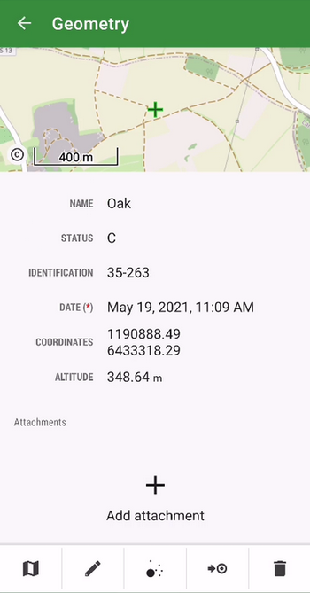
Elevation
The location of the mapped objects can now be defined by a “third coordinate” – elevation. All new projects now work with this parameter which is either computed from GPS data, can be added manually, or can be added to the items from our global DEM. The elevation values can be also exported to a Shapefile.
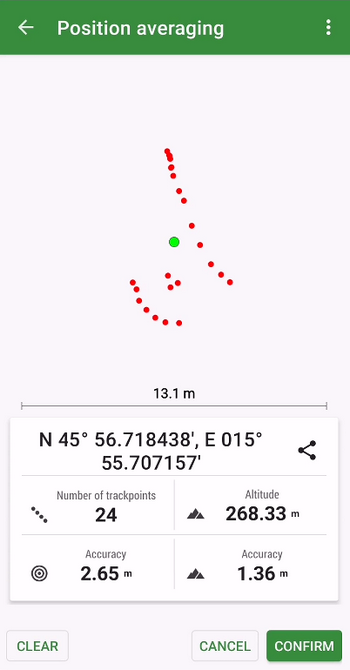
Better positioning accuracy
The app can locate objects with enhanced accuracy using position averaging. The device sends a cluster of location data to the app and Locus GIS can calculate the average (the most accurate) location.
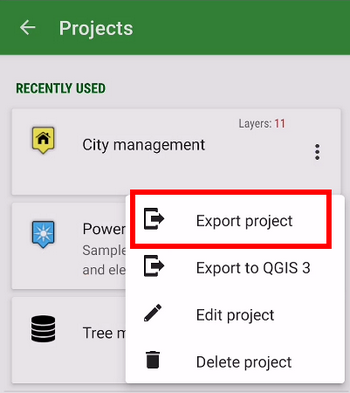
Whole project import/export
To transfer a whole project easily from one to another device or among more members of one team, we implemented an option to export/import the whole project in a .ZIP file.

Comments
2
Dobrý den, mám v mobilu neplacenou verzi Locus Gis a mám problém zobrazit CUZK jak Základní tak Ortofoto ČR online mapu po zmáčknutí tam běží okénko Inicializuji se zeleným páskem a když to doběhne objeví se oranžová hláška: “map o.iG@ce38e9a is not ready hG, code: 12591”. Co s tím? Koupil bych ale toto trvá již více než půl roku. Mám zaplacený Locus Map Classic a tam mi zůstaly natažené fragmenty a nové se mi pro další oblasti nestahují v režimu online. Tak je to asi větší problém. Jsem se motal pořád v jednom místě a tam to bylo stažené dříve.
Dobrý den,
omlouvám se za pozdní reakci. Nicméně přetrvává prosím problém? Případně jakou verzi aplikace používáte? (LocusGIS – Menu – O aplikaci/helpdesk – o aplikaci)
S Díky
Petr